TNTatlas
2019 Build 0410
Size: 58.2 GB
Downloads: 1897
Platform: Windows (All Versions)

Thanks to modern technology, the days of turning pages in a physical Atlas are long gone. A good example of this technology is TNTatlas. It gives you the possibility of viewing, analyzing, publishing and distributing geodata, which can be quite important in certain fields of work. The software is capable of reading anything, from simple geodata files to complex map layouts. Also, it lets you work with various file formats and it places a wide range of useful controls at your disposal.
TNTatlas is absolutely free and it is available for all popular Windows and Mac OS X editions. Downloading and installing the software is an uneventful task and it doesn't take more than a minute to complete it. There are no special tools or services to install and there is no need for powerful hardware.
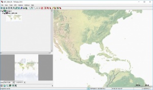
The software is not intended for inexperienced users, but it shouldn't be too difficult to learn its controls and master its functionality. You can open files in various formats, including GeoTIFF, MrSID and DWG. If the input file contains complex geodata, you will find its components neatly categorized in a tree structure, on the left side of the user interface.
Maps and other information can be viewed in the larger area, on the right side of the interface. You can zoom and pan without any restrictions and you can also bring up a focused area on Google Maps or other similar services. It is also possible to draw lines, rectangles, or other shapes, and make measurements, directly on a map.
GPS data can be loaded from external devices. If you have a GPS connected to your computer, you can import its logs, and other information, and make various tweaks, to calibrate the data and to display it in a certain way.
Regardless of how far you zoom or what annotations you make, you can take quick snapshots and save them in a local folder or print them, if you want to publish them or send them to someone who needs detailed maps of a certain area.
When it comes to opening, annotating and publishing geodata, TNTatlas can meet all your expectations.
Pros
The software can open geodata files in numerous formats. It displays a file's contents in a well organized manner. You can import GPS data, make annotations and take snapshots.
Cons
Inexperienced users will need some time to learn how to use TNTatlas.
TNTatlas
2019 Build 0410
Download
TNTatlas Awards

TNTatlas Editor’s Review Rating
TNTatlas has been reviewed by Frederick Barton on 28 Jun 2018. Based on the user interface, features and complexity, Findmysoft has rated TNTatlas 5 out of 5 stars, naming it Essential